 Nautical Necessity v.2.1.0.0
Advertisement
Description
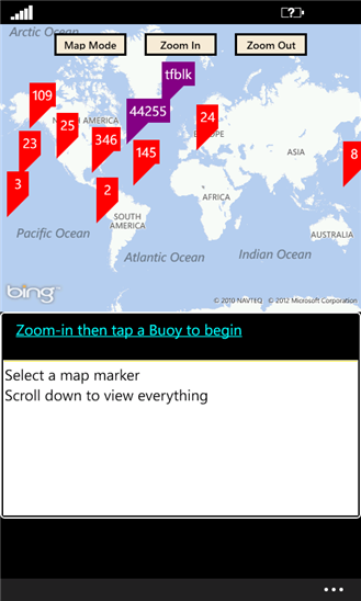
Obtains and displays near-real time NOAA buoy data for use by surfers, boaters, fisherman, hurricane watchers, weather hounds, and beach-goers.
View information from 700+ active NOAA smart-buoys, consisting of wind speed, wind direction, air temperature, water temperature, wave height, wave period, and more.
- Rate:
- Release Date:10/17/2012
- License:Freeware
- Category:Science
- Developer:Northwest Tech
- Downloads:72
- Size:1024 Kb
- Price: Free
To free download a trial version of Nautical Necessity, click here
To visit developer homepage of Nautical Necessity, click here
Advertisement
Screen Shot
Click on a thumbnail for the larger image.
System Requirements
Nautical Necessity requires Windows Phone 7.5 or higher | phone identity, owner identity, photo, music, and video libraries, data services, movement and directional sensor, HD720P (720x1280), WVGA (480x800), WXGA (768x1280) | English (United States)
Nautical Necessity v.2.1.0.0 Copyright
Shareware Junction periodically updates pricing and software information of Nautical Necessity v.2.1.0.0 full version from the publisher using pad file and submit from users. Software piracy is theft, Using crack, password, serial numbers, registration codes, key generators, cd key, hacks is illegal and prevent future development of Nautical Necessity v.2.1.0.0 Edition. Download links are directly from our publisher sites. Links Nautical Necessity v.2.1.0.0 from Bittorrent, mediafire.com, uploadfiles.com, hotfiles.com rapidshare.com, megaupload.com, netload.in, storage.to, depositfiles.com and other files hosting are not allowed. The download file is obtained directly from the publisher, not from any Peer to Peer file sharing applications such as Shareaza, Limewire, Kazaa, Imesh, eDonkey, eMule, Ares, BearShare, Overnet, Morpheus, BitTorrent Azureus and WinMX.
Review This Software
More Nautical Necessity Software
Advertisement

2010 Nautical Almanac v.1 10
Complete 2010 Nautical Almanac in pdf format.

Nautical Miles to Kilometers Converter
Have you ever had a problem converting from nautical miles to kilometers? Worry no more! With Nautical Miles to Kilometers Converter your troubles are over. With simple sliding action you can see answers instantly!

Nautical Charts v.1.0.0.0
NOAA nautical charts with animated tides and currents, markers, routing, and tracks. Charts cover the entire USA coastline. Use GPS to map your location, plan a course, mark locations,
Nautical Calendar v.1.0
Nautical Calendar is a full featured, stunningly produced Desktop ADvantage calendar based on a nautical theme with motivational saying.
AstroNav v.1.1.6
Combine multiple sights on different tracks. Data available for 9999BC to 9999AD including a Star Atlas, twilights and eclipses. It will print conventional Nautical Almanac pages while the voyage plan is a sophisticated tool in its own right.
FilesCollection
FilesCollection makes use of an Explorer-like interface to let you index the all fixed, removable media, and network drives on your system and archives on them for further fast, full and convenient search without necessity to insert discs again into the

ABC Typing lesson
The keys of early typewriters were, sensibly enough, laid out in alphabetical order. The impetus for change was not exactly the yearning for blistering speed that has brought us together here today, but rather necessity. Early typewriters were mechanical

Graybox OPC Server Toolkit
Graybox OPC Server Toolkit lets the programmer to create robust and highly effective OPC Servers within the shortest possible time. This toolkit eliminates the necessity of implementing all of the numerous OPC interfaces and COM programming. Graybox OPC
Geozip
Geozip calculates distance between US (optionally Canadian) zip codes or geographical coordinates, latitude and longitude. It does take into account the curvature of the earth for calculating. You can choose miles, kilometers or nautical miles output.
YGS Submit Browser
Program YGS Submit Browser combines an Internet browser with possibility of a fast insert of 2000 various text fragments (relieving of necessity of application of operations to "copy-paste", the password manager and generator (passwords are stored in the